Attend an Earth Day event, and you’ll probably learn that a simple way to fight climate change is by planting as many trees as you can. Sébastien de la Bastie wouldn’t argue with that, but he also has another idea involving things like laser beams and drones.
The chief business officer with Paris-based Outsight, de la Bastie’s expertise is in the rapidly evolving technology of LiDAR. A remote-sensing method invented in the 1960s as a way to track orbiting satellites, LiDAR (standing for “light detection and ranging”) uses light in the form of a pulsed laser to generate images of the surrounding environment.
Today, numerous companies make LiDAR instruments that time how long it takes for an emitted beam of light to bounce back to a sensor after striking an object. Using that information, these devices can calculate the distance the light traveled, and by repeating the process millions of times per second, produce 3D maps of their surroundings.
Last June, Outsight announced the launch of what the company calls a “first”: a real-time LiDAR solution designed specifically for the forestry industry.
Historically, de la Bastie explains, forestry managers have relied on mechanical tools like tree calipers to take various measurements on a representative number of trees, and then they’ve extrapolated that information to draw general conclusions about the forest overall. “The problem is the measurements you get are very imprecise,” he says. “And the process is laborious and time-consuming—usually around five minutes per tree.”
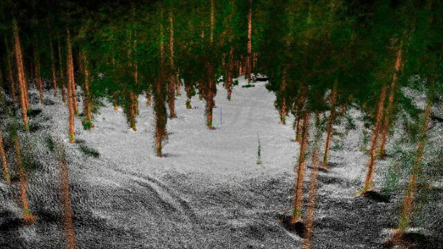
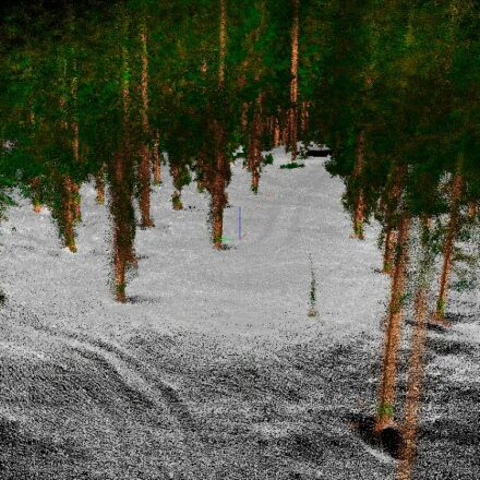
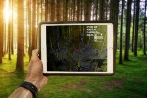
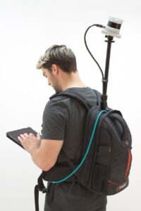
The Outsight solution, the “Augmented LiDAR Box,” is a portable unit that can fit in a small backpack. The device connects to any LiDAR sensor and instantly pre-processes collected data before sending it to the user’s tablet computer. The operator simply walks around the forest with the sensor protruding from the pack and, in a matter of minutes, has a digital model of the landscape with every tree plotted as it stands in real life.
In addition, de la Bastie notes, the device allows the user to easily add information on the unique characteristics of individual trees. They might, for example, make note of the species or tag any trees with signs of insect damage. “The biggest benefit is that it divides by 10 the time required to do a forest inventory,” he says.
Carbon calculations
Forest inventories are important: They provide scientists with critical information on everything from tree health to biodiversity. But how might a device like Outsight’s help the world combat climate change? For that, de la Bastie says, you first need to understand how carbon dioxide fits into the equation.
CO2 accounts for the vast majority of human-caused greenhouse gas emissions, he explains. Forests, on the other hand, absorb CO2 through the process of photosynthesis. By one recent estimate, forests worldwide sequester approximately 2.6 billion tons of CO2 per year. That amounts to about a third of annual CO2 emissions caused by the burning of fossil fuels.

“Most of the carbon that’s captured by a tree goes into the trunk,” de la Bastie says. “So if you have a way to measure trunk growth, you can easily extrapolate the quantity of carbon a forest is removing from the atmosphere.”
Right now, de la Bastie continues, Outsight is collaborating with researchers in France and Canada to develop new tools for their device that will use trunk measurements to automatically calculate the propensity for surveyed forests to sequester CO2. Once they have that information, scientists should be able to use it with other data pertaining to forest health to both study the effects of climate change and the results of forestry-focused mitigation efforts.
De la Bastie imagines terrestrial mapping systems like Outsight’s possibly teaming with airborne units that can put LiDAR to work at a much greater scale. “Aerial LiDAR isn’t nearly as precise as what you can get from the ground,” he says, “but combining the two could give you everything—a map of forest health across the world.”
3D digital Earth
One scientist who shares de la Bastie’s enthusiasm for LiDAR is Christopher Fisher, Ph.D. A Colorado State University archaeologist, Fisher also heads The Earth Archive, a nonprofit organization that’s using airborne LiDAR technology to build what it calls a “3D digital Earth.”
“To measure change,” Fisher says, “you have to measure against a constant. What we’re trying to do is get baseline data we can use to better address the climate crisis.”
LiDAR can now be found in a growing number of consumer applications, from robot vacuums to self-driving cars, but airborne scanning is different, Fisher says. “The technology that’s available for civilian use doesn’t have the capacity or range for what we’re trying to do here.”
As Fisher noted in a recent National Academy of Sciences opinion piece in which he called on the international community to 3D scan the planet, climate change has already reached a “critical point” and will “fundamentally disrupt weather patterns, raise sea levels, alter biogeographic distributions and much more.”
He recently led a research team that deployed LiDAR from a helicopter to scan the redwood forest in Muir Woods National Monument in California. They were able to document every tree, he says, and they used the data they collected to estimate the total carbon the forest currently holds. That dataset is now stored in The Earth Archive—he describes it as an “open-access repository”—and is available to any scientist who wants to use it.
Muir Woods is just a drop in the bucket for what he’d like to do with LiDAR, Fisher admits, but it’s also a start that he hopes will inspire others around the world to take action (and many already have).
“We need to do this now,” he adds. “If we don’t, it will be too late.”
Lead photo courtesy of Outsight