By Betsy Vereckey, contributor
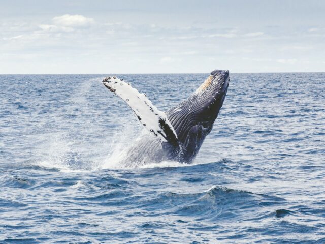
Even though blue whales are the largest creatures on Earth, they’re one of the most difficult to spot, making it incredibly challenging for scientists to track and protect this endangered species.
“They move quickly, and you see them at the sea surface for very short moments of time,” says Jeremy Goldbogen, an associate professor of oceans at the Stanford Doerr School of Sustainability, who estimates that a whale can move between 6 to 16 feet per second. “You’re lucky if you see them once.”
Harmful whaling practices nearly killed off the blue whale population in the 19th and 20th centuries, and estimates from the World Wildlife Federation suggest that no more than 25,000 blue whales remain. They live in all of the oceans except for the Arctic. Along the West Coast, where Goldbogen does his research, eastern North Pacific blue whales migrate to Mexico and Central America to spend the winter.
Twenty-five thousand whales may sound like a lot, but before whaling practices, there were as many as 250,000 blue whales. New threats are only making the problem worse: ship collisions, climate change, pollution (such as microplastics in the water) and entanglement with nets. To protect blue whales, researchers need to know their location. The solution lies in underwater acoustics technology, like a hydrophone.
“Blue whales produce calls that are easy to identify, very powerful and last a long time,” says John Ryan, an oceanographer and senior research specialist at the Monterey Bay Aquarium Research Institute (MBARI), which has been using a number of different technologies to track and protect blue whales.
Deployment of modern acoustic technology
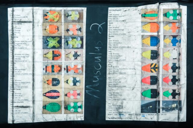
In 2019, the center installed a directional hydrophone—a special underwater microphone that records blue whale calls and identifies the direction the call came from. Their directional hydrophone can hear blue whales in an area spanning 3,800 square miles. This type of technology is a major upgrade from the satellite tags that scientists used in the early 1990s to track blue whales.
“Acoustically, blue whales make these low-frequency calls, which travel very far in water,” Goldbogen says. “Listening to the ocean is a good way to see where whales are going. Having a directional hydrophone, like MBARI does, you can hear the whale, and you can determine the bearing or the direction where that call is coming from.”
To further pinpoint the whales’ whereabouts, the researchers needed to place tags on the animals themselves, which is how Goldbogen and Ryan ended up combining data from MBARI’s hydrophone with real-time data from tracking tags that Ryan and his team placed onto whales. The collaboration helped the researchers come to a better understanding of whale behavior in the ocean and validate that a whale was calling in a specific spot at a specific time. The duo and their team have recently published research conducted between 2019-21 on the central California coastline, which Ryan calls an “essential foraging habitat,” as blue whales love to feed on krill along the shelf break in Monterey Bay.
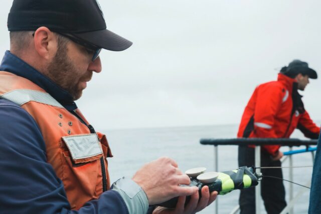
Attaching the tracking tags wasn’t an easy process. The scientists went out in small boats, and when a whale surfaced, they deployed the tag using a long carbon fiber pole. However, “new drones are getting so effective that people are now dropping these from drones onto whales,” Goldbogen says.
The tag that they used had four suction cups that attached to a whale. The tag would eventually fall off somewhere between 12 and 24 hours but completed an extraordinary amount of work in that time period. “The tag only stays on for a day or two, but we’re sampling 500 times a second in terms of the animal movement,” Goldbogen says.
Listening to the ocean is a good way to see where whales are going. [With] a directional hydrophone you can hear the whale, and you can determine the direction where that call is coming from.
—Jeremy Goldbogen, associate professor, Stanford University
After the tag fell off, it floated to the top of the ocean via a flotation device, and a transmitter allowed researchers to track the tag and get it back. Once retrieved, they downloaded the data inside. A video camera on the front of the tag provided a visual, while a hydrophone provided audio. There were also additional sensors on the tag, including an accelerometer (which measured acceleration), a magnetometer (which measured a magnetic field) and a gyrometer, which measured rotational speed. Each tag was around $15,000 and could be reused.
The tags were crucial because they validated with the hydrophone that a whale was calling in a specific spot at a specific time. All whale calls that the hydrophone “heard” during the sampling period registered on the tag’s accelerometer, which strongly suggested they were from the tagged whale.
Tracking helps with conservation and climate change
Scientists have long known that blue whales seasonally occupy Monterey Bay during the upwelling season (when the wind drives nutrient-rich cold water from the bottom of the ocean upward toward the surface). But this new research shows that whales can track the upwelling process on an incredibly fine scale.
There is still much to learn about how whales know where to forage for krill, however. “Wind causes the strong coastal upwelling, and whales could hear that—that’s one possibility,” Ryan says. Cold water and other whales calling are other possibilities, as is a whale’s memory of where good spots were previously. “They could remember—they have spatial memory,” Ryan says. “They have a memory like an elephant, and they could be using this to remember the fixed locations along the coast.”
Blue whales seek out this cold water because it’s where krill are most abundant. When this so-called upwelling stops, blue whales move offshore into areas unfortunately transected by shipping lanes.
Ship strikes are “one of the greatest threats to the recovery of this population,” Ryan says. “Previous studies using tags have shown that blue whales aren’t very good at avoiding ship strikes.”
But thanks to this research, we know more about whale behavior, and ships can adjust their routes accordingly. One mapping tool called Whale Safe, for example, shows whale and ship data for the Santa Barbara Channel with the goal of reducing whale-ship collisions.
Acoustic technology, such as a directional hydrophone and location tags, scale up the ability to understand what whales are doing in big ocean basins that are otherwise really difficult to operate in. Says Goldbogen, “We can see if whales change their behavior in response to an environmental change, or we might be able to inform the shipping industry by saying, ‘Hey, there’s actually a group of whales in the shipping lanes. Can you decrease your speed a little bit in order to reduce the risk of a ship strike?’ which is a well-known cause of mortality of large whales on this coast.”
There are also implications regarding climate change. Goldbogen referenced a “blob” of hot ocean water that is considered to be a consequence of climate change. “Because of that, krill were smaller,” and this had “direct consequences for blue whales, which only eat krill.”
“If that were to happen again, that would be one way where we could actually get some more direct information about how a climate-induced perturbation like that would change the oceanography, and therefore the food that these whales depend on,” Goldbogen says.
In the future, Goldbogen says technology will make it much easier to eavesdrop on whales in the ocean and better protect them. “Technology really opens up a lot of different possibilities,” he says. “When high school students come up to me and say they want to be a marine biologist, I say, ‘That’s awesome. You should do it and learn how to code and learn a programming language.” Having computational abilities is key in marine biology and oceanography, he explains. “It allows us to make the most out of the big data era that we now live in.”
Lead photo courtesy of Thomas Kelley/Unsplash.